- الصفحة الرئيسية /
- إلكترونيات /
- GPS, Finders & Accessories /
- Sports & Handheld GPS /
- Handheld GPS Units /
- PPK, NOAA RTK GNSS Survey Equipment GPS Recei...




منتج #:
143127275
PPK, NOAA RTK GNSS Survey Equipment GPS Receiver with IMU Rover & Base Handheld Collector Land Surveying Equipment, Survey Software(Include
91% من المشترين سيوصون بهذا المنتج لصديق
منتج #:
143127275
EGP 171035
تفاصيل السعر
باستثناء رسوم الشحن والجمارك ( سيتم احتساب رسوم الشحن والجمارك عند إتمام الشراء )
*سيتم استيراد جميع العناصر من أمريكا
1%
0 ratings
اكتب رأيك
متوفر فى المخزون
 مستورد من متجر USA
معاملة آمنة
تعمل يوباي جاهدة لحماية أمنك وخصوصيتك. يضمن نظام أمان الدفع المتقدم لدينا السرية من خلال تشفير معلوماتك أثناء النقل باستخدام بروتوكولات AES (معايير التشفير المتقدمة) وSSL (طبقة المنافذ الآمنة). تفاصيل الدفع الخاصة بك آمنة بنسبة %100 لأننا لا نشارك تفاصيل الدفع الخاصة بك مع بائعين تابعين لجهات خارجية
أفضل شركائنا اللوجستيين


Unsurpassed Precision: Our RTK technology ensures centimeter-level accuracy, providing you with reliable measurements for the most demanding surveying tasks.
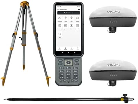
تحتوي هذه الحزمة على 3 من العناصر


شحن
سريع

استرجاع
مجاني*

تغليف آمن

منتجات أصلية %100

الامتثال لمعيار PCI DSS

حاصل على شهادة ISO 27001



Note: Step Down Voltage Transformer required for using electronics products of أمريكا store (110-120). Recommended power converters اشتري الآن.


مايفيد
Precision GNSS
Utilizes NOAA RTK technology for high-accuracy land surveying, minimizing errors in data collection, making it ideal for professionals requiring exact measurements.
Integrated IMU
Includes an Inertial Measurement Unit for enhanced stability and accurate positioning in challenging environments, significantly improving survey results over traditional methods.
Comprehensive Package
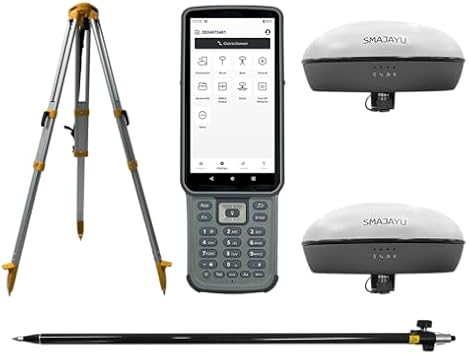
Complete solution with GPS receiver, handheld collector, pole, tripod, and survey software, providing everything needed for effective land surveying in one convenient package.
تفاصيل المنتج
| Additional Features | Lightweight |
| Compatible Devices | Smartphone |
| Brand | SMAJAYU |
| Model Name | Surveying Equipment |
| Built-In Media | GNSS Receiver, Handheld Collector, Other accessories, Surveying Pole, Surveying Tripod |
| Manufacturer | SMAJAYU |
| Number of Items | 1 |
| Model Number | SMA20 |
| Mfr Part Number | SMA20 |
| Special Feature | Lightweight |
| Included Components | GNSS Receiver, Handheld Collector, Other accessories, Surveying Pole, Surveying Tripod |
| Item Weight | 7.2 lbs (3.27 kg) |
ما بداخل الصندوق
GNSS Receiver
Handheld Collector
Surveying Tripod
Surveying Pole
Other accessories
من يجب أن يشتري؟

-
Professional Surveyors
Ideal for experienced surveyors needing precise location data for large land projects with high accuracy requirements.
-
Geospatial Engineers
Great for geospatial engineers working on mapping and designing infrastructure projects requiring advanced GNSS technology.
-
Agricultural Planners
Beneficial for agricultural planners looking to optimize land use and crop monitoring with reliable GNSS support.

-
Casual Users
Not suitable for casual users needing simple location data, as it offers complex features not necessary for basic use.
وصف المنتج
هل لديك أي استفسار؟ تحدث معنا
أسئلة العملاء & الإجابات
-
سؤال:
What is the PPK, NOAA RTK GNSS Survey Equipment GPS Receiver used for?
إجابه: The PPK, NOAA RTK GNSS Survey Equipment GPS Receiver is designed for high-precision land surveying tasks. It provides real-time kinematic (RTK) positioning, ensuring accuracy in data collection for applications like topographic mapping, construction layout, and geospatial analysis. This equipment is critical for professionals needing reliable geolocation data, such as civil engineers, land surveyors, and environmental consultants, allowing for effective project planning and execution. -
سؤال:
How does the IMU enhance the performance of the GNSS Receiver?
إجابه: The Inertial Measurement Unit (IMU) integrated into the GNSS receiver enhances positioning accuracy by compensating for satellite signal outages and providing orientation information. It enables the system to maintain position and orientation data during dynamic conditions, such as when a surveyor is moving. This is particularly useful for projects that require mobility, like aerial surveys or large-scale site mapping, as it ensures continuous data integrity. -
سؤال:
What is included with the GNSS Survey Equipment package?
إجابه: The GNSS Survey Equipment package typically includes the PPK receiver, IMU rover, base station, handheld collector, and essential accessories such as a pole and tripod. This comprehensive set ensures that users have everything they need to begin surveying right away. The pole and tripod help stabilize the equipment, ensuring accurate data collection in various terrain conditions, making it well-suited for both urban and rural projects. -
سؤال:
Can this equipment be used for hydrographic surveying?
إجابه: Yes, the PPK, NOAA RTK GNSS Survey Equipment can be effectively used for hydrographic surveying. Its high-precision capabilities allow for accurate underwater positioning and mapping, which is essential for projects such as dredging, marine construction, and environmental monitoring. By integrating with specialized software, users can create detailed bathymetric maps, enhancing the effectiveness of waterway management and marine research. -
سؤال:
What types of survey software are compatible with this equipment?
إجابه: The GNSS Survey Equipment is compatible with various survey software solutions designed for processing GNSS data. Users can utilize software such as Trimble Business Center, Leica Geo Office, or generic data processing tools that support RTCM formats. These software solutions facilitate data post-processing, enabling users to generate accurate survey reports and digital elevation models essential for project analysis and decision-making. -
سؤال:
How do I setup the base station with the rover?
إجابه: Setting up the base station with the rover involves positioning the base station at a known control point and configuring its settings to broadcast correction signals. The rover, once positioned at the survey site, receives these signals to improve positional accuracy. This configuration is vital for achieving centimeter-level accuracy in land surveying, especially in applications like boundary surveys and construction stakeouts where precision is crucial. -
سؤال:
Is the equipment portable for field use?
إجابه: Yes, the PPK, NOAA RTK GNSS Survey Equipment is designed for portability, making it suitable for field use. The handheld collector is lightweight and can be easily carried, while the collapsible tripod and pole facilitate efficient setup in various environments. This portability is essential for professionals conducting surveys across large sites or remote areas, ensuring they can efficiently gather data without cumbersome equipment. -
سؤال:
What is the accuracy level of the GNSS Receiver?
إجابه: The PPK, NOAA RTK GNSS Survey Equipment GPS Receiver achieves accuracy levels often within 1-2 cm, depending on environmental factors and configuration. This high level of precision is critical for land surveying tasks requiring detailed data collection, such as legal boundary determination, topographic mapping, and infrastructure development. The robust performance in diverse conditions ensures reliable results for professionals across multiple industries. -
سؤال:
What type of batteries does the GNSS Receiver use?
إجابه: The GNSS Receiver typically uses rechargeable lithium-ion batteries, ensuring a reliable power source for extended surveying tasks. These batteries are designed for longevity and can sustain prolonged use in the field. With the ability to recharge quickly, surveyors can efficiently manage their time and workload, particularly during comprehensive surveying projects, minimizing downtime while ensuring continuous operation. -
سؤال:
Where can I buy PPK, NOAA RTK GNSS Survey Equipment GPS Receiver in Egypt?
إجابه: You can buy the PPK, NOAA RTK GNSS Survey Equipment GPS Receiver, including the IMU rover and base handheld collector, from Ubuy in Egypt. Ubuy is known for its extensive collection of high-quality surveying equipment and offers convenient purchasing options for professionals in need of reliable GNSS solutions.
SMAJAYU Handheld GPS Units SMA20 Editorial Review
لم يتم العثور على مراجعات تحريرية
مراجعات العملاء وتقييماتهم
1 تقييمات العملاء
-
5 نجمة
0%
-
4 نجمة
100%
-
3 نجمة
0%
-
2 نجمة
0%
-
1 نجمة
0%
أضف تقييم لهذا المنتج
شارك أفكارك مع عملاء آخرين
منصة موثوقة وثقة كاملة للمشتري

MA
Mohammad
مشتري موثّق
“Excellent quality and original too,when ubuy send original things I will appreciate that ,I very satisfied thank you”
23 July 2026 · عبر Trustpilot
CK
Chitra
مشتري موثّق
“The order and delivery progress was communicated very well. Package arrived within the estimated time. Products arrived as expected in good condition.”
22-Jul-26 · عبر Trustpilot
K
kund
مشتري موثّق
“Good supply of products. Safe payment methods, and shipment worldwide! Genuine products.”
23-Jul-26 · عبر Trustpilot
OO
Onesi
مشتري موثّق
“Was my first time buying a product from Ubuy, but I found it so helpful. This is reliable. Gonna place a new order!”
22 July 2026 · عبر Trustpilot
SJ
SAO JOHN
مشتري موثّق
“Ubuy is a great online platform to buy stuff. Reliable, fast delivery time and great value for money. I've been using Ubuy online shopping platform for three years now and will continue to do so.”
23 July 2026 · عبر Trustpilot
الخروج الآمن
شحن عالمي
إسترجاع سهل
منتجات أصلية
Related Categories
الماركات التجارية ذات الصلة
تاريخ سعر المنتج
معلومات مهمة
- القيود: بالنسبة للمنتجات التي يتم شحنها دولياً، يُرجى ملاحظة أن أي ضمان من الشركة المصنعة قد لا يكون صالحاً؛ قد لا تتوفر خيارات خدمة الشركة المصنعة؛ قد لا تكون أدلة المنتج والتعليمات وتحذيرات السلامة مكتوبة بلغة بلد المقصد؛ قد لا يتم تصميم المنتجات (والمواد المصاحبة لها) وفقاً لمعايير بلد الوجهة والمواصفات ومتطلبات الملصقات؛ وقد لا تتوافق المنتجات مع الجهد الكهربي المستخدم في بلد الوجهة والمعايير الكهربائية الأخرى (تتطلب استخدام محوّل كهربي أو جهاز تحويل إذا كان ذلك مناسباً). المستلم مسؤول عن ضمان إمكانية استيراد المنتج بشكل قانوني إلى بلد الوجهة. عند الطلب من يوباي أو الشركات التابعة لها، يكون المستلم هو المستورد المسجل ويجب أن يلتزم بجميع القوانين واللوائح الخاصة ببلد الوجهة.
- ليست كل المنتجات المدرجة على يوباي معروضة للبيع، لأن يوباي هو محرك بحث عالمي. المنتجات تخضع للوائح التصدير / التجارة.
EGP 171035
اطلب الآن واحصل عليه حول الثلاثاء, سبتمبر 15
هذا المنتج غير ممنوع في بلدي. (الرجاء الضغط على الرابط أعلاه إذا لم يكن هذا المنتج ممنوعاً في بلدك ، لذلك سيقوم فريقنا بمراجعته والسماح به.)
كمية:
بقي 7 فقط من المنتج في المخزن.
معاملة آمنة
نوفر لك مدفوعات مشفّرة، وحماية متكاملة للمشتري، مع الالتزام بمعايير PCI DSS وشهادة ISO 27001:2022 لضمان أعلى مستويات الأمان في كل عملية شراء.
أفضل شركائنا اللوجستيين
أسرع توصيل عبر الحدود
المميزات والفوائد
- Achieve centimeter-level accuracy with advanced RTK technology.
- Ideal for topographic, geographic, engineering, and agricultural surveying.
- NOAA certified for reliability and performance.
- PPK capability allows for operation in challenging environments up to 25km.
- Supports multiple constellations for versatile applications.
- Data output compatible with various formats for easy integration.
ضمان Ubuy
تسوّق بثقة مع منتجات أصلية %100، ومدفوعات آمنة متوافقة مع معيار PCI DSS، وحماية بيانات معتمدة وفق ISO 27001، وشحن دولي سريع، وإرجاع مجاني*، وتغليف آمن لكل طلب.